Hallowes Crescent
Named after Hallowes Golf Club, in Dronfield, Derbyshire, England.
The 1896 map shows what was here before the estate. Drag the round handle to compare it with today.
The name
Hallowes Crescent takes its name from Hallowes Golf Club. Golf began there in 1890 or 1891 when locals asked farmer Ashton for leave to play over his fields, and into the early 1900s sheep, horses and haystacks were still hazards on the course.
Club dates: 1892 (as Dronfield GC, renamed Hallowes 1896).
Where the club's facts come from: Our History, Hallowes Golf Club, the club's own history.
How sure we are of the match: Strong
The estate's streets were named after golf courses. The streets page explains how each match was made.
In the story
- Building the Estate: The estate goes up
John Swain dates the houses at the western end of Hayling Road to late 1950, and says that by the summer of 1951 the houses in the roads running off it, Dumfries Close, Nairn Green, Handsworth Way, Ashburnham Drive and Hallowes Crescent, would all be finished, a date for building work rather than for tenants moving in. - Life on the Estate: Shops, pubs and services
The first shops opened in Little Oxhey Lane in 1949, Prestwick Road gained two shops, a bank and an off-licence in 1952, Hallowes Crescent was trading by the middle of 1951, and the precinct around St Andrew's Road, the big shops, became the heart of the estate. - Shops, pubs and services: Hallowes Crescent, from 1951
The parade at Hallowes Crescent served the west end of the estate, and it opened earlier than most accounts of it say. - Getting about: Buses
The 346B began on 7 January 1953 as a feeder to Carpenders Park station, running between Hallowes Crescent and Little Oxhey Lane at Ormskirk Road by way of Hayling Road and Prestwick Road, Mondays to Fridays at peak hours only. - Rebuilding the centre: Planning permission
Countryside applied in January 2016 for up to 458 homes on the centre and homes on three smaller "satellite" sites: open space at Maylands Road, the site of the Jet pub on Hayling Road and the old services club at Hallowes Crescent. - Streets of 1947 to 1953
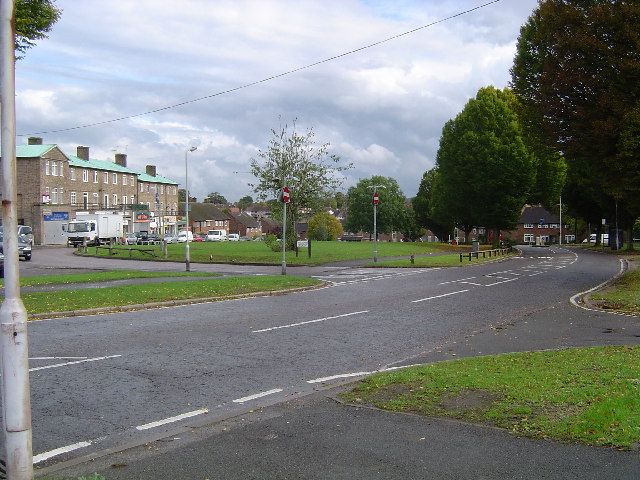
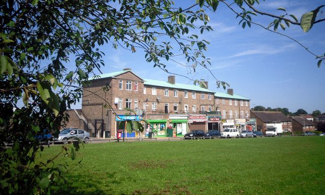
Hallowes Crescent shops: The parade that served the west end, photographed by the council in February 1953. - Health centre, Oxhey Drive
In March 1999 the surgery in Hallowes Crescent, threatened with closure two years before, was revived, with a doctor from the Oxhey Drive health centre working there two days a week. - The Crescent Club (site)
The Crescent Club, once the Services Club, was a social club in Hallowes Crescent, and work on its building began on 6 November 1971. - Hallowes Crescent shops
This parade served the west end of the estate, and a resident who grew up nearby remembers a hardware shop with the sub-post office, a baker, a butcher, a grocer and a chemist.
On the timeline
- Early 1953 A parade of shops opens in Hallowes Crescent, at the west end of the estate.
- 7 January 1953 The 346B bus begins as a peak hours feeder to Carpenders Park station, running between Hallowes Crescent and Little Oxhey Lane.
- 6 November 1971 Work starts on a £30,000 services club in Hallowes Crescent, later the Crescent Club.
- September 2016 Work begins with the demolition of Baden Hall, the old Scout hall on Henbury Way, and of the Crescent Club on Hallowes Crescent.
- Spring 2018 The first residents move into new affordable homes on Hallowes Crescent and Maylands Road and into the first flats in the centre.
Close by
Buildings
- Hallowes Crescent shops 30 m
- The Crescent Club (site) 30 m
- Salvation Army hut (site) 50 m
- Oxhey Woods Local Nature Reserve 90 m
- The Jet (site) 440 m
Ancient woods
- Oxhey Woods, northern part (Old and Young Hangings, Little Furze Field, The Plantation) 90 m
- Hampermill Spring and Round Spring 160 m
- Big Wood 280 m
Walk stops
- Hallowes Crescent shops 30 m
Streets of 1947 to 1953 walk - Ashburnham Drive entrance 130 m
The lost golf course walk - Round Spring and Hampermill Spring 260 m
The lost golf course walk
Distances are in a straight line from a point on the street.